My Most Recent Munro's
(Completed at Last)
June 2014
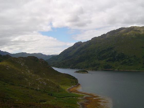
Skye At last the time had come to complete the "Munro's" and a two day trip to Skye was set.
Sgurr Mhic Choinnich Parked at the end of the Glenbrittle road just beside the campsite and headed up the path towards Corie Lagan and to the An Stac screes. There are a few ways through the scree but it is still a battle, I found it better to stay on the bigger stones which eventually come out on the ridge.
 From there you turn right and have a short descent before scrambling up the rocks. That was the easy bit because now there is a short steep climb with a fair bit of exposure before the summit itself is reached.
The return route is tricky as that steep ascent now has to be reversed, after that it is fairly straight forward back to the ridge and down the screes again and back to the campsite.The photo on the left shows the scrambling part from the top of the screes to the summit of Sgurr Mhic Choinnich
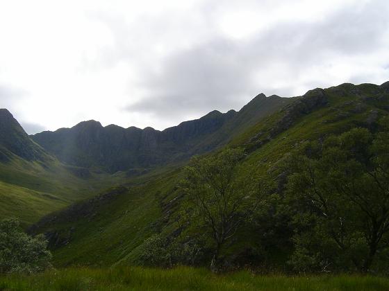
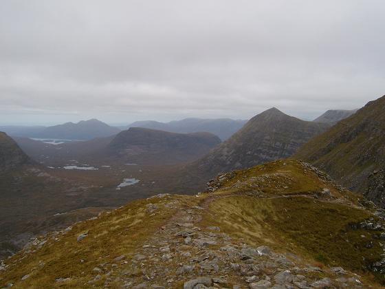
Am Basteir Started this time at Sligachan where there is a well made path opposite the Mountain Rescue Post, this leads to a couple of bridges and into the Basteir Gorge. But to get into the gorge it is necessary to ascend the steep slabby stones, and I just found this a difficult route finding exercise, but after a few false moves I did get into the gorge and headed left towards the scree. There are a few paths up on the left side, but as always scree is hard work but it does take you onto the ridge between Sgurr nan Gillean and Am Basteir.
From the bealach it is up the ridge on the right, some of this ascent is on slabs and they can be slippy, quite soon there is a short vertical drop, it is tricky and a rope helps, especially on the return. After that it is a short scramble to the summit. The day I climbed this hill it was misty and a bit wet, maybe just as well I couldn't see all that exposure, but it did make photos impossible.
August 2012
Knoydart I have waited a while to visit "The Rough Bounds", but can't put it off any longer.
Kinloch Hourn to Barrisdale To get to the car park there is a 22 mile drive along narrow single track road with many ups and downs
 and in the final 3 miles or so there seems to be less passing places and the corners are a bit scary.
The private car park costs Ł2 per night and the owner also runs a small tea shop which is very welcome before setting off.
The whole route in (about 7 miles 3 -3 1/2 hours) is easy to follow, a bit rough in places and there are a few smallish hills to
ascend.
I was lucky in that the weather was perfect and the views over the loch towards Sgurr na Sgine and the Forcan Ridge are excellent, and
quite soon the first sight of Labhar Bheinn comes into view.
 Some houses appear on the opposite bank and a bit further on the path joins the Land Rover Track close to the boathouse, now there is only
1 mile to the bothy and campsite.
Some houses appear on the opposite bank and a bit further on the path joins the Land Rover Track close to the boathouse, now there is only
1 mile to the bothy and campsite.
The bothy is very good, 12 bunks, cold running water, a toilet and best of all electric light. Even if all the bunks are taken there is
space on the floor for sleeping bags. The campsite opposite is a bit rough, but campers can use the facilities of the bothy especially to
escape the midges. Great place, and at only Ł3 per night for the bothy and Ł1 for the campsite, super value.
Ladhar Bheinn The way I climbed it was on leaving the bothy, cross the bridge and turn right along a well trodden path towards the
hillside, the path from here zig zags up the hill through ferns and round the shoulder into Coire Dhorrcail, the path is well made and when
you come to the Allt Coire Dhorrcail, cross over and climb the grassy slopes towards the ridge. Once on the ridge, there is a path, which
although there is a bit of handwork will take you to a split, the right goes to the summit, the left is a way down. It is only a few yards
 from here that the quite unexciting cairn of the summit lies, the trig point is a little further on, but this is the highest point.
On the descent I walked south east to the lowest point and dropped down rather wet and slippy grass into Coire Dhorrcail, from there it was
a matter of following the stream back to my route of ascent.
Unfortunately all the time I was on the ridge and summit there was low cloud, and it was not until I dropped into the Coire the tops
cleared. (The story of my life) Many of the books send walkers other ways, and it looked to me that they involved a bit more climbing and
some of the descent a bit hairy, so I felt that the way I went was as easy as possible
Meall Buidhe and Luinne Bheinn Again from the bothy, over the bridge and follow the path to Inverie as far as the high point on the Mam Barrisdale where there is a large cairn marking the path to the summits.
My intended way up was over the south east ridge to the summit of Luinne Bheinn, but the mist was quite thick so I followed my planned line  of descent, a line of old metal fence posts up to the wide apron between the two peaks. From here I turned south west over very rough ground and eventually to the summit of Meall Buidhe, the cloud was still down so I quickly returned to the head of the coirre and started up Luinne Bheinn.
As I was half way up the shoulder the mist cleared and I was treated to spectacular views of the surrounding mountains poking their heads  through the clouds, the sight was amazing and in all my years of hill walking I have never seen such a fantastic view.
Now on the summit of Luinne Bheinn, with a clear sky, I was able to enjoy the scenery denied me so far on this trip, and it was worth the wait.
Still it was time to go, and I dropped down the south east ridge towards the Mam Barrisdale, there was a path for most of this way but I lost it near the bottom, but the main path was visible and the rest was easy. From here back down to the bothy at Barrisdale.
Overall, a good day out, quite a lot of rough ground and following the fence posts was decidedly muddy, but the views were worth it all.
July 2012
Sgurr Dearg Started this one from Glenbrittle Memorial Hut and followed the path uphill heading for the ridge, the  path is quite good until the shoulder is reached then it becomes very loose and zig zags a bit, some handwork is required here too.
 It soon levels of a bit until the next part where unfortunately for me the mist came down, so unfortunately no views,so it was follow the faint path, again some handwork needed.
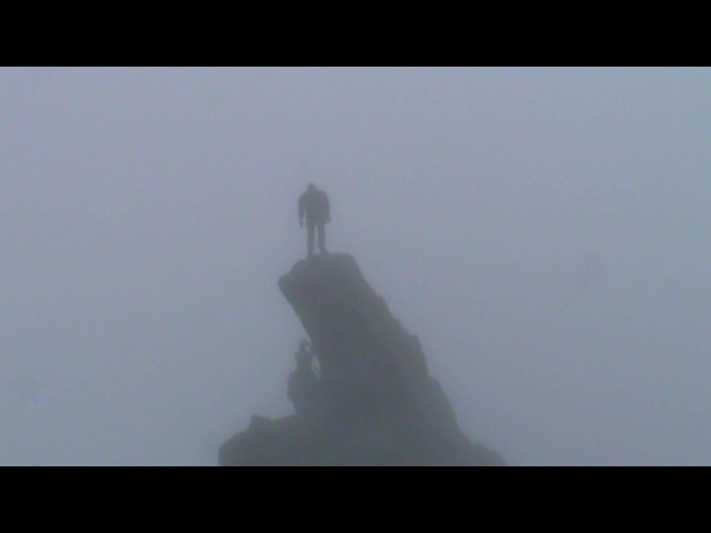
Quite soon however the peak was reached and the great lump of rock which is the Inn Pin looms from the mist, it is certainly an impressive sight and nerves of steel are required to ascend the exposed east ridge and abseil the west side especially in conditions on that day.
The return route can be made either by the Coire Laggan Scree or the route of ascent.
July 2012
Sgurr nan Gillean I set out from just beside the Mountain Rescue Post at Sligachan and followed the path which crosses two bridges and into Coire Riabhach, around here there is a split in the path, and the one for the peak is to the left towards steeper and rougher ground.
From here and to climb up to the south east ridge involves quite a lot of loose rocks, boulders and sheer determination is needed to get there, but once on the ridge the views begin to open out and the task ahead looms.
Ahead there is a bit of exposure and scrambling in places and my advice is don't look down, needless to say there isn't a lot of room on the summit but the views are wonderful
Descent is the same as the way up, but take care on the first few places until you reach the main lower ridge.
June 2012
Sgurr na Sgine The next day saw a great improvement in the weather with bright skies and sunshine.
I parked in a lay by on the A87, crossed the road and onto the very well made path which quickly takes you up to a height of almost 500m, from here simply follow the path to the 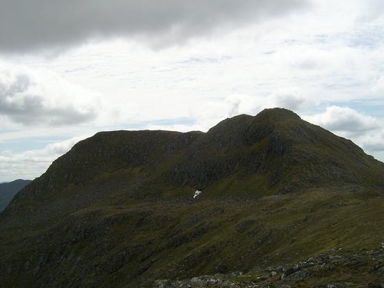 split, right for the Forcan Ridge or left to where I was heading; the Bealach Coire Mhalagain between the Forcan and Sgurr na Sgine.
Turning south here, there is a faint path over some quite stony ground all the up the hill to level grassy area below the ascent towards my target.
Sgurr na Sgine has three tops, and of course the Munro is the most far away one, it is easy 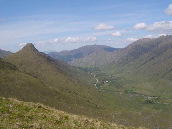 to reach and there are wonderful views over many hills including Knoydart, Glen Shiel and even Ben Nevis.
To add a bit of variety, I returned by way of Faochag, this hill looks almost impossible to climb from the road, but there is a well made track all the way down, it is quite steep in places but is easy to follow and gives excellent views of the Forcan Ridge all the way back to the road.
May 2012
An Socach New Munro's are getting further away, so I made a two day trip to the Shiel Bridge area and stayed at the SYHA Ratagan Hostel.
On the first day I awoke to the sound of my worst enemy; rain, it wasn't heavy so I made my way to Killilan, parked there and cycled the 8 miles up Glen Elchaig to Iron Lodge.
 A good part of this road is tarmacked, then becomes a Land Rover Track, there are not too many uphill parts and the scenery is well worth the effort.
By the time I got to Iron Lodge (about an hour) the weather had not improved, the tops were all covered in mist but I'd come this far and carried on. From here the path narrows and there are a few steep, loose sections up to Loch Mhoicean, from here it is across the grass  and take a north easterly direction to the bealach just north of Meall Shuas, then a little level ground before the steep pull up to An Socath.
From about the bealach the weather closed in and it became a map and compass job, pity really but that is how it is sometimes.
Return was back down the same way, and just as Murphy's Law dictates the sum came out as I arrived back at Iron Lodge. The cycle run back to the car park was quite easy as there was more downhill than coming in.
Quite a long hard day, but worth the effort.
September 2010
Liathach - Spidean a' Choire Leith and Mullach an Rathain
These were two hills I had been avoiding due to their reported exposed nature and the need for 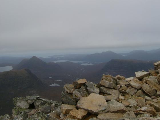
 some serious scrambling, but as things turned out my fears were unfounded and the day proved to be one of the most enjoyable I have had for a while.
I drove up to Kinlochewe on a Friday afternoon and stayed in the bunkhouse which is attached to the Kinlochewe Hotel, it is a bit basic with bunks three high, nowhere to sit and shock horror no tin opener. But the showers were good and parking was easy.
The walk itself starts at a parking area on the A896 and up a well constructed path, higher up the path turns right and after a couple of minor scrambles over rocks you arrive on the col of the main ridge
Turn left here and climb over two rather bouldery tops before reaching the ascent of Spidean a' Choire Leith. This part, like the whole walk is on an easy to follow path but does have one or two very mild scrambles but nothing to get excited about.
 The descent to the next col involves following a very loose and sometimes exposed path, but it very soon brings you to the choice; Scramble or Not to Scramble.
My decision was easy, the path on the south side.
The descent to the next col involves following a very loose and sometimes exposed path, but it very soon brings you to the choice; Scramble or Not to Scramble.
My decision was easy, the path on the south side.
Although this path is narrow there are no difficulties and I found it quite exhilarating, winding below the pinnicles and finally arriving close to Am Fasarinen at 927m and the perfect lunch stop.
The final pull was to Mullach an Rathain is quite easy and along a good path to the peak at 1300m. Excellent views all along the route.
The descent into the corrie starts a few metres beyond the summit and goes down a very loose zig zag path onto more stable ground near the stream and eventually onto the road some mile and a half from the start point.
A very enjoyable day which I highly recommend.
Sgurr a' Mhadhaidh, Sgurr a' Ghreadaidh
The next five hills are part of the Black Cuillins in Skye and start in Glen Brittle.
 Starting from the SYHA in Glen Brittle the path follows the burn into Coire a' Ghreadaidh and towards Coire an Dorus, from here it is up the scree towards the coll. The going here is quite loose and need at little care.
 The route up to Sgurr a' Mhadhaidh is a bit awkward at first but soon levels a bit but still is a scramble to the small cairn at the summit, the reason for a small cairn seems to be that there is no room for anything bigger. Just a short stop to take photos and off to the next top.
Once back on the coll the ascent to Sgurr a' Ghreadaidh is just as difficult at first, but there is a path quite soon which bypasses a tower of rock to the right and leads to the summit of Sgurr a' Ghreadaidh. Again a very narrow ridge and certainly not roomy enough to accommodate many climbers posing for photos.
Return is by the upward route, through the loose scree and back on the path to the Youth Hostel.
Sgurr Dubh Mor, Sgurr nan Eag
Starting this time at the camp site in Glen Brittle there is s path twards Coire Lagan and then branches right across the moor towards Sron na Ciche and Coir' a' Ghrunnda, the going to the entry into Coir' a' Ghrunnda is easy, but that is about to change.
The path I took was to the left and close to the rocks, not too bad at first but as you gain height it involves a bit of scambling and rock hopping to reach the lochan.
Again I stuck to the left side of the corrie and climbed the ridge, from here it is over an easy peak before dropping down and scrambling up Sgurr Dubh Mor summit.
Back down and heading towards Sgurr nan Eag, this involves negotating some ledges and following a path to the left side and onto the ridge and the rather fine cairn at the summit.
The return is back the ascent route, staying to the rocks on the right this time and back to Glen Brittle.
Sgurr Alasdair
Again starting at the camp site in Glen Brittle and the path towards Coire Lagan and the Loch Coire Lagan, this is passed on the left side. Now the biggest challenge of the day is in sight "The Great Stone Chute"
This is mass of loose rocks and scree and although there is a path through it, the going is very tiring.
I found it easier to keep to the bigger rocks on the right side, but going is slow up the gully to the coll. From there it is a bit of a scramble up to the summit of Sgurr Alasdair but the views from here are spectacular.
Return is back down the Stone Chute and into Glen Brittle.

May 2010
A' Mhaighdean, Ruadh Stac Mor, Beinn a' Chlaidheimh, Sgurr Ban, Mullach Coire
Mhic Fhrearchair and Beinn Tarsuinn.
This trip was made to the Fisherfield area, which is near Ullapool and Dundonnell,
This was to one of the most remote parts of Scotland containing Munro's.
The walk begins at Corrie Hallie, which is at the road side of the A835 and follows a land rover track then an often muddy
path over the hills to Shenavall Bothy The bothy is one of the most popular in Scotland as to
climb these hills usually means at least one overnight stay.
 The bothy has two rooms downstairs and a large area for sleeping upstairs. The setting is
fantastic with mountains all around and plenty of wildlife everywhere.
The bothy has two rooms downstairs and a large area for sleeping upstairs. The setting is
fantastic with mountains all around and plenty of wildlife everywhere.
There was plenty space when I visited, over the three nights there were only a maximum of three
of us at any one time.
Next day I left at around 9.00am to walk A' Mhaighdean and Ruadh Stac Mor, this meant a total
of four river crossings, but as conditions had been very dry I was lucky with the water being only
ankle deep.
The entire path to the start of the climb could not have been better and was easy to follow to the
bealach between the two hills, then simply head down and up to the summits. 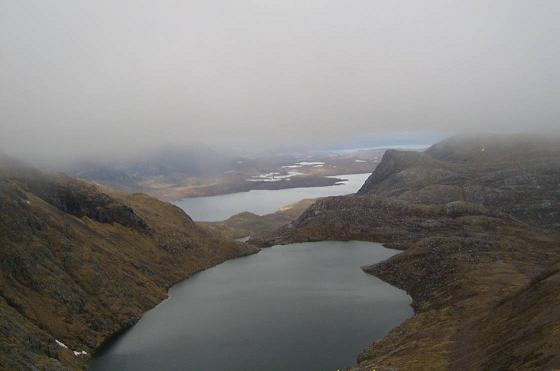 The weather was a bit misty but
a couple of clear spells made the effort worthwhile.
The weather was a bit misty but
a couple of clear spells made the effort worthwhile.
From Ruadh Stac Mor the desent was north then north east back to the path and return to Shenavall.
The next outing was set to be longer and took in Beinn a' Chlaidheimh, Sgurr Ban, Mullach Coire
Mhic Fhrearchair and Beinn Tarsuinn.
From the bothy, the climb up the north west shoulder of Beinn a' Chlaidheimh looked a
bit severe, so I started a little east of there and crossed the river roughly where the land rover track comes
in from Corrie Hallie. It was still a long climb up the north east shoulder of the hill to the ridge and
the col just south of Beinn a’ Chlaidheimh’s summit. This was mostly over heather and grass and
then stones near the top
The next one is Sgurr Ban.
On the way down from Beinn a’ Chlaidheimh there are two small lochans at the col. Then it was a
just a slog up the hillside which is covered with rocks and boulders, this requires a lot of care.
There is a large round stone cairn at the summit.
From Sgurr Ban, the next summit, Mullach Coire Mhic Fhearchair is definately the most
gruelling of the day. You can see the route of ascent snaking up the hillside and it looks and was
very steep. 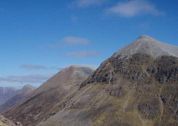
Beinn Tarsuinn is the final one of the day.
There is a descent south from the Mullach Coire Mhic Fhearchair and then along a path which
follows the contours of the steep side of Meall Garbh. That leads nicely to the final ascent of
Beinn Tarsuinn.
 From here it was a matter of picking a way down into Gleann na Muice to rejoin the path and
return to Sheavall and onwards to Corrie Hallie.
From here it was a matter of picking a way down into Gleann na Muice to rejoin the path and
return to Sheavall and onwards to Corrie Hallie.
Overall, an excellent couple of walks in one of the most remote parts of Scotland, the position of
Shenavall Bothy is crucial to the expedition and is very popular; anyone making this trip is well
advised to carry a tent just in case you hit a busy time there.
September 2009
This outing saw the base as Ardmair Point Caravan Site near
Ullapool, we had been waiting on a break in the weather, and here it
was.
 The first day Eididh na Clach Geala, Meall nan Ceapraichean,
Cona'Mheall and Beinn Dearg.
The first day Eididh na Clach Geala, Meall nan Ceapraichean,
Cona'Mheall and Beinn Dearg.
Start on the A835 at the head of
Loch Broom and through the Leal Forest road and up Glenn na Sguaib on
the north side of the River Leal.
This path branches left after a while and I followed this and climbed
the slopes to the summit of Eididh na Clach Geala, 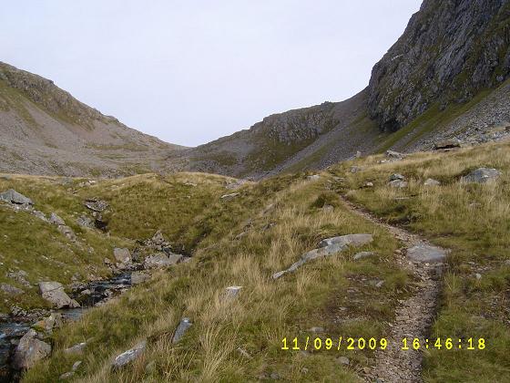 then in a general
south east direction towards Meall nan Ceapraichean, and easterly
towards Cona'Mheall. From here it was back to the Bealach an Lochain
Uaine and by following the old drystane dyke up to the summit of Beinn
Dearg
then in a general
south east direction towards Meall nan Ceapraichean, and easterly
towards Cona'Mheall. From here it was back to the Bealach an Lochain
Uaine and by following the old drystane dyke up to the summit of Beinn
Dearg
The return route is back to the bealach and follows the path back down
to the start point
A long but very rewarding day on a mixture of paths and grass, the
cloud did break on occasions and the four hills are not too difficult
to bag in a day.
While in the Ullapool area I also walked Seana Bhraigh, the
start was again the A835 at Inverleal forest and followed the same
route for a couple of miles before branching east onto the Druim na
Saobhaidhe, this path seems to go on forever but eventually disappears
making life difficult in mist, but I eventually followed the compass to
an unnamed top at 905 m and quite soon later the summit of Seana
Bhraigh.
The return route is a reversal of the ascent.
This is long outing and definitely a walk for a clear day because the
path comes and goes and a compass bearing took me through some very wet
ground.
September 2009
This walk saw me back at Gerry's Hostel in Glen Carron to
tackle Bidein a' Choire Sheasgaich, Lurg Mhor and Fionn
Bheinn.
The first part of this route I had been before and used the bike as far
as the wire bridge over the Alt Chonais and up the path to the Bealach
Bhearnais.
This is when the fun really began as usual for me it was wet and
misty and the path just seemed to disappear, so again it was compass
and determination that got me through.
This was a day spent climbing descending and climbing again, it just
never seemed to stop.
Eventually I reached the top of Bidein a' Choire Sheasgaich and later
the summit of Lurg Mhor, and returned the same way (I think) to the
bealach before dropping down and back to the roadway and the bike down
the hill.
I certainly felt these two were well earned and an glad I don't have to
go back.
No photos here, just too misty.
The next day, and on the way home,I drove back to Achnasheen and walked Fionn Bheinn,
the start is at the station car park, across the road, through the farm
and up the path beside the burn.
Care is needed as it is easy to stay following the burn, but it is
necessary to branch north east towards the summit of Creagan nan Laogh
and a faint path leads all the way to the top of Fionn Bheinn. The
return route is back the same way.
This is a short day, but don't underestimate it, some of the route I
found to be across rough grass and often pathless, and on the day I did
it there was a very strong wind blowing and some of the final approach
is close to the cliff edge.
Again just too misty a bit too windy to get the camera out.
August 2009
The base for the first of those was a two day trip was Cannich, near Loch Ness.
Day one to Mam Sodhail, Carn Eighe and Beinn Fhionnlaidh
started from the car park near Affric Lodge and took me west along the
path and north/west into Coire Leachavie. The first part of this climb
is on quite a rough road and then grass and wet ground before gaining
the path which was easy to follow upwards and onto the south west
shoulder of Mam Sodhail
 The descent and ascent to Carn Eighe was fairly easy but is quite a
hefty drop and quite a long way before the ascent to the summit of
Beinn Fhionnlaidh.
The descent and ascent to Carn Eighe was fairly easy but is quite a
hefty drop and quite a long way before the ascent to the summit of
Beinn Fhionnlaidh.
Most of the day was spent in mist, but it did clear on occasions and
being quick with the camera gave me a couple of photos.
On the way back it is back over all the already climbed tops and a very
heavy shower of rain did not help, then back down Coire Leachavie and
the return route beside Loch Affric.
Overall a good day 3 more tops bagged.
The next day I drove round to Loch Cluanie and walked the wettest 6
miles I seen for a long time through the An Caorrann Mor to Alltbeithe
Hostel.
 The next morning I started quite early on the ascent of An Socach,
Sgurr nan Ceathreamhnan and Mullach na Dheiragain.
The next morning I started quite early on the ascent of An Socach,
Sgurr nan Ceathreamhnan and Mullach na Dheiragain.
Fairly easy going up the path behind the hostel and onto the ridge,
then east to the rather uninteresting top of An Socach before returning
to the bealach and crossing Stob Coire Cloiche and the summit of Sgurr
nan Ceathreamhnan, then north east along the ridge to Mullach na
Dheiragain.
From there it was back along the ridge and drop to Loch Coire nan
Dearcag and climbing up towards the bealach and rejoining the path
which leads back to the hostel.
Not a bad days walking most of which was on paths and as usual the
cloud was down on the summits.
July 2009
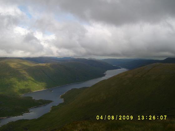
Two weeks earlier I was off again, this time to Glen Dessarry area, the target here was Sgurr nan Coireachan, Garbh Chioch Mhor, Sgurr na Ciche and on the second day Sgurr Mor
I stayed at Glen Roy, which meant an hour drive along a single track switchback road to the end of Loch Arkaig.
At first the walk is along a land rover track,  then a narrow path before climbing the southern ridge of Sgurr nan Coireachan, from the summit I could see what lay ahead.
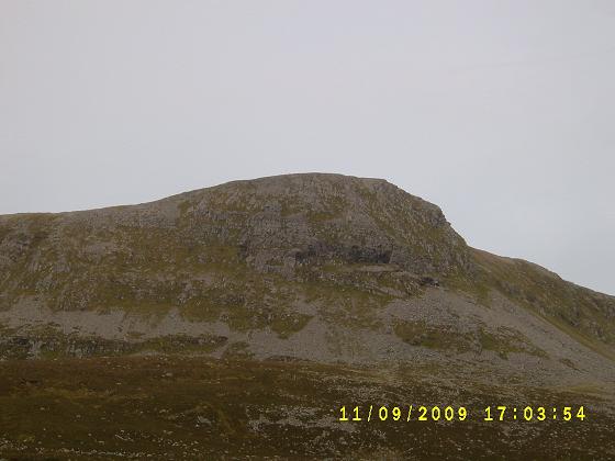
It was quite a steep descent before climbing beside a wall and a couple of minor tops to the summit of Garbh Chioch Mhor (photo right) 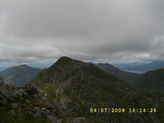 and lunch time at last.
Then a steep drop over rocks to a col and up a very rough and eroded path to the top of Sgurr na Ciche (photo left).
The return route of about 12k was rough at first then back on the path and road of the outward route.
A long day of 11 hours and 17k, but well worth the effort.
Next day it was back along Loch Arkaig and the walk along the estate road to just before the Glendessary buildings, it is here that you leave the road and head for a gate then onto a path and over the col between Fraoch Bheinn and Drum a' Churin towards the River Kingie, the ground so far had been a bit muddy, but the river was reasonable and crossing was quite easy.
It was now a steep climb up the slopes to the col between Sgurr Mor and Sgurr an Fhuarain, then along the path to the summit of Sgurr Mor. Return was by the same route.
This was quite a bit further than I had anticipated, but rewarding to have managed it over ground which sometimes is very, very wet.
June 2009
These were two, two day trips,  the first was in the Ullapool area Which is located
in the north west coast of Scotland and is the sailing point to Stornoway in the Western Isles.
the first was in the Ullapool area Which is located
in the north west coast of Scotland and is the sailing point to Stornoway in the Western Isles.
Like the last visit I made to this area I stayed at The SYHA Hostel in Ullapool, a very busy place with good facilities and all the advantages of a town too.
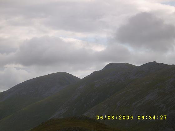
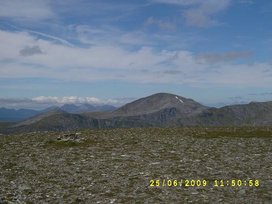
The first day I climbed Ben Liath Mhor Fannaich (954m), Sgurr Mor (1110m), Meall Gorm (949) and An Coileachan (923m).
These hills form part of the Fannaichs, which is a group of nine Munros close to the A835 road and offer a variety of ground from short grass to peat haggs and boulder fields.
The walk started beside the A835 road at the north west end of Loch Glascarnoch, first following the river and then the ridge of to the summit of 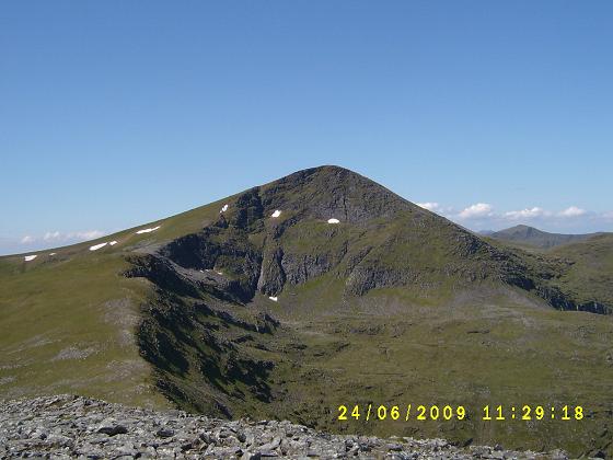 Ben Liath Mhor Fannaich, then a sharp boulder strewn drop before the climb up to Sgurr Mor (photo left).
The views from here are amazing and I was lucky to have a clear day.
Still, lots more to do, so it was a descent over grassy steps and fairly easy terrain to the summit of Meall Gorm.
Walking these four hills together has the advantage that the hard ascent is at the beginning of the day and the individual climbs are not too severe, so apart from a couple of rough parts I soon was ready to tackle the final top.
As I had to return to this point to make my return I left my rucsack at the bealach and climbed the grass and stone slope to the summit of An Coileachan which has a cairn on top of a small crag.
Now the work really started with a sharp descent to a small loch and a trackless walk over heather and peat bogs back the the path which eventually lead back to the roadside.
This was a long tiring day covering 23k and a total ascent of 1200m, in all it took me 10 hours, but the weather was excellent and apart from the last bit was easy going.
The next day I walked Am Faochagach and the start was exactly the same as the day before beside the A835.
 Across the road and follow the path over wet grass to the river which can be a problem to cross but given the dry weather it was quite easy, then soon it was up towards the coll and north over a minor top before a sharp pull over grass and stones to the summit. (photo left showing Beinn Dearg)
Quite a flat top with a small cairn and affording good views of the previous days walk.
The return route is a reversal of the ascent, so it didn't take too long to be back in the car and heading home.
Once again a very pleasant two days and 5 more Munros off the list.